mail_outline sales@mediastorehouse.com
Choose a picture from our Images Dated 2nd March 2010 Collection for your Wall Art and Photo Gifts
394 items
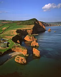
Aerial image of Rock Stacks, Otter Sandstone of Triassic age, Ladram Bay, Devon, England, United Kingdom, Europe
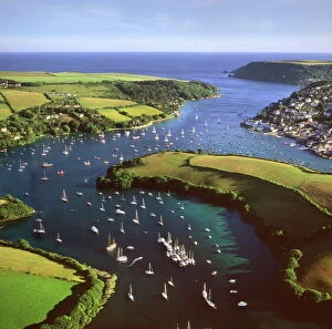
Aerial image of Salcombe and East Portlemouth, Kingsbridge Estuary, Devon, England, United Kingdom, Europe
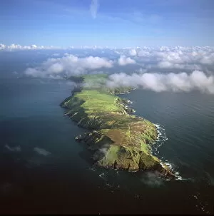
Aerial image of Lundy Island looking from north to south, Bristol Channel, Devon, England, United Kingdom, Europe
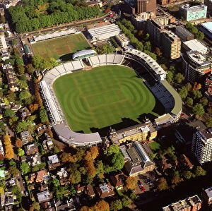
Aerial image of Lords Cricket Ground, St. Johns Wood, London, England, United Kingdom, Europe
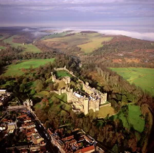
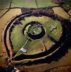
Aerial image of Arundel Castle, a restored medieval castle, South Downs, Arundel, West Sussex, England, United Kingdom, Europe
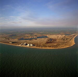
Aerial image of Dungeness Nuclear Power Station, Dungeness headland, Kent, England, United Kingdom, Europe
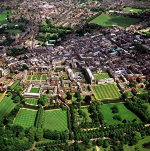
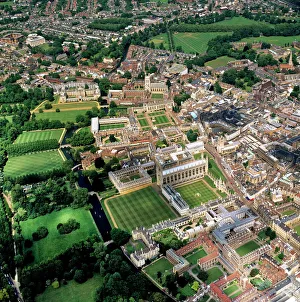
Aerial view of Cambridge including The Backs where several University of Cambridge colleges back on to the River Cam, Cambridge, Cambridgeshire, England, United Kingdom, Europe
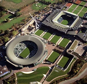
Aerial image of Centre Court and Number 1 Court, All-England Club (All England Lawn Tennis and Croquet Club), Wimbledon, London, England, United Kingdom, Europe
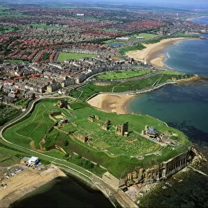
Aerial image of Tynemouth Priory and Castle, on a rocky headland known as Pen Bal Crag, Tyne and Wear, England, United Kingdom, Europe
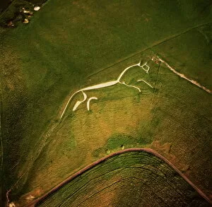
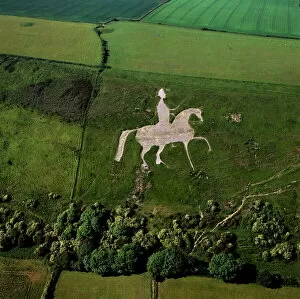
Aerial image of the Uffington White Horse, Berkshire Downs, Vale of White Horse, Oxfordshire, England, United Kingdom, Europe
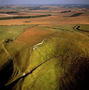
Aerial image of Uffington White Horse with Uffington Castle hill fort, Berkshire Downs, Vale of White Horse, Oxfordshire, England, United Kingdom, Europe
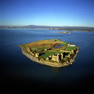
Aerial image of Piel Castle (Fouldry Castle) (Fouldrey Castle), a concentric medieval fortification with a keep and three towers, Piel Island, Furness Peninsula, Barrow in Furness, Cumbria, England
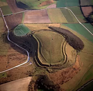
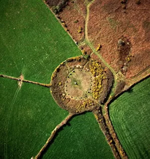
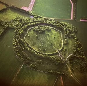
Aerial image of Badbury Rings, an Iron Age hill fort, Dorset, England, United Kingdom, Europe
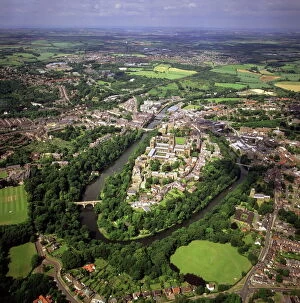
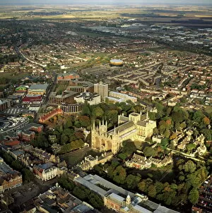
Aerial image of city including Durham Castle, a Medieval castle, Norman Cathedral, and the River Wear, Durham, England, United Kingdom, Europe
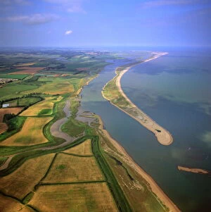
Aerial view of Orford Ness (Orfordness), a cuspate foreland shingle spit, Suffolk, England, United Kingdom, Europe
Aerial view of Peterborough Cathedral and city, Peterborough, Cambridgeshire, England, United Kingdom, Europe
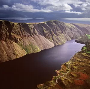
Aerial image of Wastwater Screes and Wast Water (Wastwater), the deepest lake in England, a good example of a glacially over-deepened valley, Wasdale Valley, Lake District National Park, Cumbria
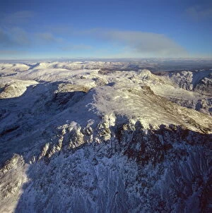
Aerial image of Scafell Pike, the highest mountain in England, Lake District National Park, Cumbria, England, United Kingdom, Europe
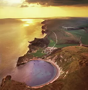
Aerial image of Lulworth Cove, a natural landform harbour, near West Lulworth, on the Jurassic Coast, UNESCO World Heritage Site, Dorset, England, United Kingdom, Europe
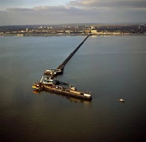
Aerial image of Southend Pier, the longest pleasure pier in the world, and estuary of the River Thames, Southend-on-Sea, Essex, England, United Kingdom, Europe
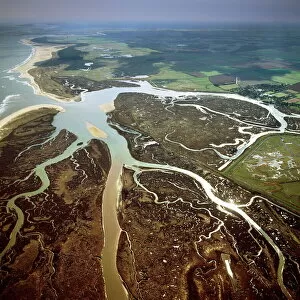
Aerial view of salt marsh at Burnham Overy Staithe, Norfolk, England, United Kingdom, Europe
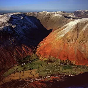
Aerial image of Wasdale Head, with St. Olafs church, the smallest church in England, Brackenclose, Wasdale Fell, Kirk Fell, High Fell and Mosedale, Lake District National Park, Cumbria, England
Aerial image of Battlesbury Camp, an Iron Age Hill fort, Warminster, Wiltshire, England, United Kingdom, Europe
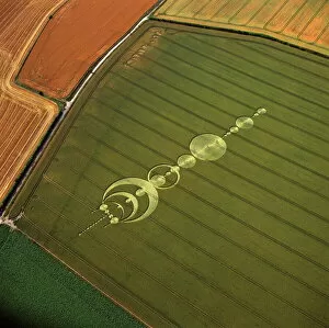
Aerial image of crop circle, Wiltshire, England, united Kingdom, Europe
Aerial image of car depository at Sheerness, Isle of Sheppey, Kent, England, United Kingdom, Europe
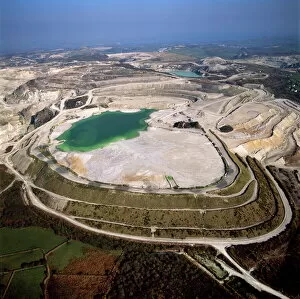
Aerial image of China Clay (Kaolin) Quarries, St. Austell, Cornwall, England, United Kingdom, Europe
Aerial image of Boscawen-Un Stone Circle, with gorse flowers, St. Buryan, Cornwall, England, United Kingdom, Europe
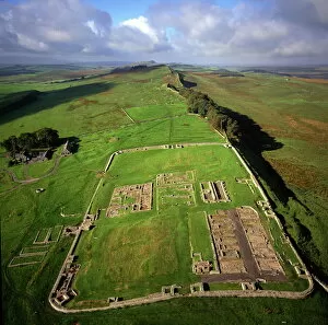
Aerial image of Housesteads Roman Fort of Vercovicium, an auxiliary fort on Hadrians Wall, UNESCO World Heritage Site, Northumberland, England, United Kingdom, Europe
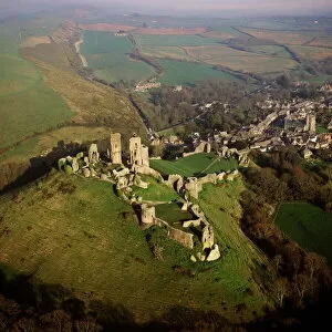
Aerial image of Corfe Castle, Purbeck Hills, between Wareham and Swanage, Dorset, England, United Kingdom, Europe
Aerial image of Old Sarum, the original site of Salisbury with castle ruins and cathedral foundations inside two high Iron Age banks (earthworks), Wiltshire, England, United Kingdom, Europe
Aerial image of crop circle, Wiltshire, England, United Kingdom, Europe
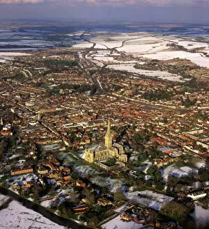
Aerial image of Salisbury Cathedral and city in snow, Salisbury, Wiltshire, England, United Kingdom, Europe
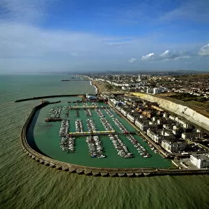
Aerial image of Brighton Marina, Brighton, Sussex, England, United Kingdom, Europe
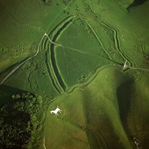
Aerial image of Oldbury Camp Hill Fort with Cherhill White Horse, Cherhill Down, Calne, Wiltshire, England, United Kingdom, Europe
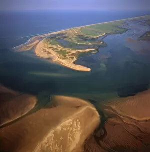
Aerial view of Blakeney Point, Norfolk, England, United Kingdom, Europe
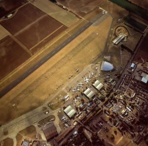
Aerial view of Duxford Aerodrome, now Imperial War Museum Duxford and the American Air Museum, Cambridgeshire, England, United Kingdom, Europe
Aerial view of Osmington White Horse, Cherhill Downs, Osmington, Dorset, England, United Kingdom, Europe
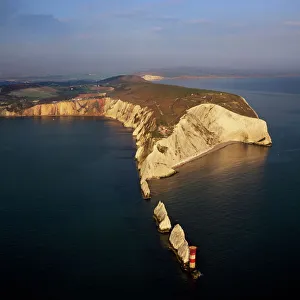
Aerial image of The Needles, a row of three chalk stacks, and Lighthouse, off the western extremity of the Isle of Wight, Alum Bay, Isle of Wight, England, United Kingdom, Europe
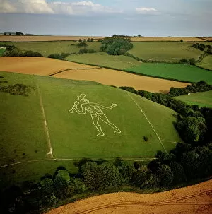
Aerial image of the Cerne Abbas Giant, Cerne Abbas, Dorset, England, United Kingdom, Europe
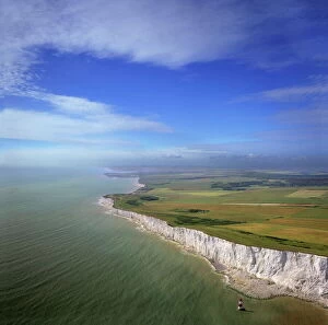
Aerial image of chalk cliffs and lighthouse at Beachy Head, near Eastbourne, East Sussex, England, United Kingdom, Europe
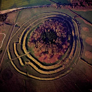
Aerial image of Danebury Ring, an Iron Age hill fort, Wiltshire, England, United Kingdom, Europe
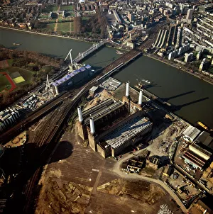
Aerial image of Battersea Power Station, an unused coal-fired power station on the south bank of the River Thames, Battersea, London, England, United Kingdom, Europe
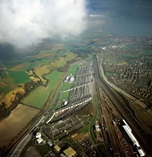
Aerial image of entrance to The Channel Tunnel (Chunnel) (Eurotunnel), beneath the English Channel, Kent, England, United Kingdom, Europe
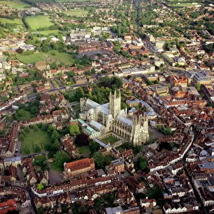
Aerial image of city and cathedral, Canterbury, Kent, England, United Kingdom, Europe
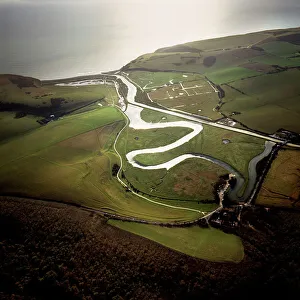
Aerial image of the Cuckmere River at Cuckmere Haven, Seven Sisters Country Park, East Sussex, England, United Kingdom, Europe
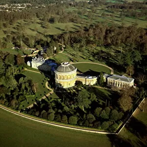
Aerial image of Ickworth House, a neoclassical country house in a park laid out by Capability Brown, near Bury St. Edmunds, Suffolk, England, United Kingdom, Europe
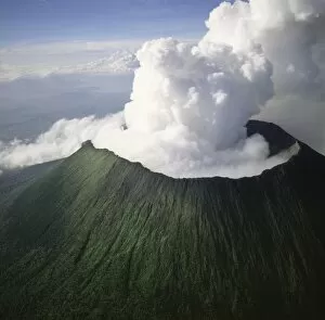
Aerial view of Mount Nyiragongo, an active volcano in the Virunga Mountains in Virunga National Park, near the border with Rwanda, known for its recent devastating eruptions